
Chaharmahal and Bakhtiyari Province topographic map
Interactive map
Click on the map to display elevation.
About this map
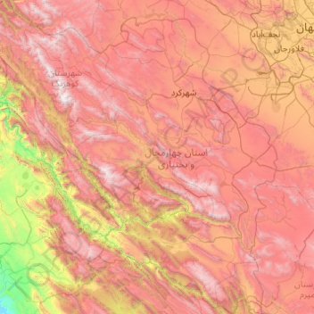
Name: Chaharmahal and Bakhtiyari Province topographic map, elevation, terrain.
Location: Chaharmahal and Bakhtiyari Province, Iran (31.14987 49.50008 32.80907 51.43433)
Average elevation: 2,064 m
Minimum elevation: 215 m
Maximum elevation: 4,153 m
Other topographic maps
Click on a map to view its topography, its elevation and its terrain.
Baba Jan, East Azerbaijan
Iran > East Azerbaijan Province > Ahar County > دهستان قشلاق
Average elevation: 1,752 m
Qom
The city's topography in the 10th century still reflected the evolutionary merging of the original six villages; these were still separated by fields. The town center was located in the village of Mamajjān, which was connected to other parts of the city on the other side of the river by four bridges. There…
Average elevation: 959 m