
Thank you for supporting this site ❤️
Make a donation
Make a donation
Catadau topographic map
Click on the map to display elevation.
Thank you for supporting this site ❤️
Make a donation
Make a donation
About this map
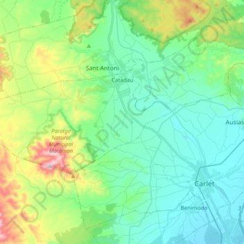
Name: Catadau topographic map, elevation, terrain.
Average elevation: 149 m
Minimum elevation: 32 m
Maximum elevation: 491 m
Thank you for supporting this site ❤️
Make a donation
Make a donation
Other topographic maps
Click on a map to view its topography, its elevation and its terrain.
Masía de la Pereta
España > Comunidad Valenciana > Castellón > Villahermosa del Río
Average elevation: 987 m
Thank you for supporting this site ❤️
Make a donation
Make a donation