
Thank you for supporting this site ❤️
Make a donation
Make a donation
Llan topographic map
Click on the map to display elevation.
Thank you for supporting this site ❤️
Make a donation
Make a donation
About this map
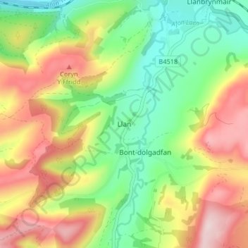
Name: Llan topographic map, elevation, terrain.
Location: Llan, Powys, Wales, SY19 7DW, United Kingdom (52.57280 -3.67031 52.61280 -3.63031)
Average elevation: 232 m
Minimum elevation: 77 m
Maximum elevation: 433 m
Thank you for supporting this site ❤️
Make a donation
Make a donation
Other topographic maps
Click on a map to view its topography, its elevation and its terrain.