
Thank you for supporting this site ❤️
Make a donation
Make a donation
Bradford topographic map
Click on the map to display elevation.
Thank you for supporting this site ❤️
Make a donation
Make a donation
About this map
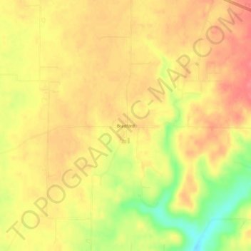
Name: Bradford topographic map, elevation, terrain.
Location: Bradford, Harrison County, Indiana, 47164, United States (38.34784 -86.08192 38.38784 -86.04192)
Average elevation: 250 m
Minimum elevation: 204 m
Maximum elevation: 274 m
Thank you for supporting this site ❤️
Make a donation
Make a donation
Other topographic maps
Click on a map to view its topography, its elevation and its terrain.