
Monte Grappa topographic map
Interactive map
Click on the map to display elevation.
About this map
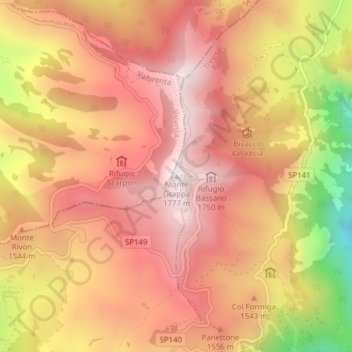
Name: Monte Grappa topographic map, elevation, terrain.
Location: Monte Grappa, Pieve del Grappa, Treviso, Venetien, Italien (45.87338 11.79915 45.87348 11.79925)
Average elevation: 1,502 m
Minimum elevation: 992 m
Maximum elevation: 1,772 m
Other topographic maps
Click on a map to view its topography, its elevation and its terrain.
Confin
Italien > Venetien > Treviso > Vittorio Veneto
Confin, Vittorio Veneto, Treviso, Venetien, 31029, Italien
Average elevation: 184 m
Valdobbiadene
Italien > Venetien > Treviso > Valdobbiadene
Valdobbiadene, Treviso, Venetien, 31049, Italien
Average elevation: 548 m