
Thank you for supporting this site ❤️
Make a donation
Make a donation
Fox Run topographic map
Click on the map to display elevation.
Thank you for supporting this site ❤️
Make a donation
Make a donation
About this map
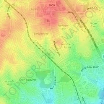
Name: Fox Run topographic map, elevation, terrain.
Average elevation: 210 m
Minimum elevation: 176 m
Maximum elevation: 238 m
Thank you for supporting this site ❤️
Make a donation
Make a donation
Other topographic maps
Click on a map to view its topography, its elevation and its terrain.
Thank you for supporting this site ❤️
Make a donation
Make a donation
Olde Georgetowne
United States > North Carolina > Mecklenburg County > Charlotte
Average elevation: 194 m
Oakdale Forest
United States > North Carolina > Mecklenburg County > Charlotte
Average elevation: 227 m
Thank you for supporting this site ❤️
Make a donation
Make a donation
Hope Park
United States > North Carolina > Mecklenburg County > Charlotte > Hope Park
Average elevation: 233 m
Country Roads
United States > North Carolina > Mecklenburg County > Charlotte > Country Roads
Average elevation: 199 m
Thank you for supporting this site ❤️
Make a donation
Make a donation