
Make a donation
Treeville topographic map
Click on the map to display elevation.
Make a donation
About this map
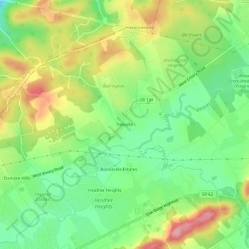
Name: Treeville topographic map, elevation, terrain.
Average elevation: 319 m
Minimum elevation: 257 m
Maximum elevation: 404 m
Make a donation
Other topographic maps
Click on a map to view its topography, its elevation and its terrain.
Knoxville
United States > Tennessee > Knox County
According to the United States Census Bureau, the city has a total area of 104.2 square miles (269.8 km2), of which 98.5 square miles (255.2 km2) is land and 5.6 square miles (14.6 km2), or 5.42%, is water. Elevations range from just over 800 feet (240 m) along the riverfront to just over 1,000 feet (300 m) on…
Average elevation: 307 m
Knoxville
United States > Tennessee > Knox County
Knoxville features a diverse topography characterized by its position in the Great Appalachian Valley. The city sits at an elevation of approximately 886 feet above sea level, nestled between the Great Smoky Mountains to the east and the Cumberland Plateau to the west. This geographical setup results in a…
Average elevation: 307 m
Make a donation
Halls Crossroads
United States > Tennessee > Knox County
It is located at 36°04′49″N 83°56′33″W / 36.08028°N 83.94250°W / 36.08028; -83.94250. It has an elevation of 1,040 feet.
Average elevation: 346 m
Make a donation
Victor Ashe Park
United States > Tennessee > Knox County > Knoxville > Windsor Park
Average elevation: 314 m
Knoxville
United States > Tennessee > Knox County
According to the United States Census Bureau, the city has a total area of 104.2 square miles (269.8 km2), of which 98.5 square miles (255.2 km2) is land and 5.6 square miles (14.6 km2), or 5.42%, is water. Elevations range from just over 800 feet (240 m) along the riverfront to just over 1,000 feet (300 m) on…
Average elevation: 307 m
House Mountain
United States > Tennessee > Knox County
House Mountain is a mountain located in Corryton, Tennessee, United States, about 8 miles (13 km) northeast of Knoxville. Rising to an elevation of 2,064 feet (629 m) above sea level, House Mountain is the highest point in Knox County.
Average elevation: 394 m
Make a donation
Knoxville
United States > Tennessee > Knox County
According to the United States Census Bureau, the city has a total area of 104.2 square miles (269.8 km2), of which 98.5 square miles (255.2 km2) is land and 5.6 square miles (14.6 km2), or 5.42%, is water. Elevations range from just over 800 feet (240 m) along the riverfront to just over 1,000 feet (300 m) on…
Average elevation: 307 m
Halls Crossroads
United States > Tennessee > Knox County
It is located at 36°04′49″N 83°56′33″W / 36.08028°N 83.94250°W / 36.08028; -83.94250. It has an elevation of 1,040 feet.
Average elevation: 346 m
Make a donation