
Make a donation
Linhares topographic map
Click on the map to display elevation.
Make a donation
Linhares
Located in the municipality of Linhares is one of the largest remnants of the Atlantic Forest in Brazil, including the Goytacazes National Forest, the Comboios Biological Reserve, the Sooretama Biological Reserve, and the Vale Natural Reserve (the largest private Atlantic Forest reserve in the country). The latter is the only place where a rare Atlantic Forest tree, the endangered Buchenavia pabstii, is still found. Due to its extremely flat topography, Linhares has 69 lagoons, some of them large, such as the Juparanã Lagoon, which is 26 km long and up to 5.5 km wide. These lagoons are a major tourist attraction, regularly visited by thousands of people.
Make a donation
About this map
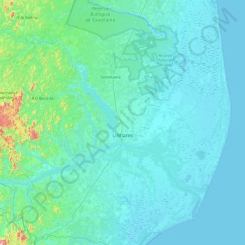
Name: Linhares topographic map, elevation, terrain.
Average elevation: 56 m
Minimum elevation: -3 m
Maximum elevation: 780 m
Make a donation
Other topographic maps
Click on a map to view its topography, its elevation and its terrain.
Make a donation
Make a donation
Pico da Bandeira
Brazil > Espírito Santo > Ibitirama
Pico da Bandeira is also remarkable for being the Brazilian mountain with the greatest topographic isolation: 2,344 km (1,457 miles). This means that at less than that distance, there is no other point on the surface of the Earth at equal or greater elevation. In the Americas, only Aconcagua, Denali, Pico de…
Average elevation: 2,488 m
Make a donation