
Thank you for supporting this site ❤️
Make a donation
Make a donation
Wilhelminaberg topographic map
Click on the map to display elevation.
Thank you for supporting this site ❤️
Make a donation
Make a donation
About this map
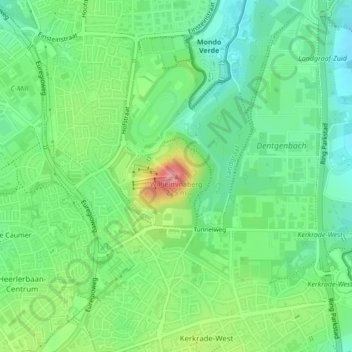
Name: Wilhelminaberg topographic map, elevation, terrain.
Location: Wilhelminaberg, Landgraaf, Limburg, Nederland, 6372VG, Nederland (50.87555 6.02542 50.87565 6.02552)
Average elevation: 147 m
Minimum elevation: 113 m
Maximum elevation: 212 m
Thank you for supporting this site ❤️
Make a donation
Make a donation
Other topographic maps
Click on a map to view its topography, its elevation and its terrain.