
Thank you for supporting this site ❤️
Make a donation
Make a donation
Savissivik topographic map
Click on the map to display elevation.
Thank you for supporting this site ❤️
Make a donation
Make a donation
About this map
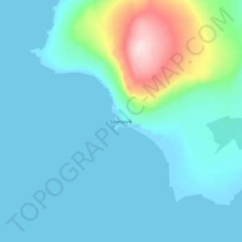
Name: Savissivik topographic map, elevation, terrain.
Location: Savissivik, Avannaata, Greenland (75.99964 -65.13430 76.03964 -65.09430)
Average elevation: 48 m
Minimum elevation: -1 m
Maximum elevation: 332 m
Thank you for supporting this site ❤️
Make a donation
Make a donation
Other topographic maps
Click on a map to view its topography, its elevation and its terrain.