
Thank you for supporting this site ❤️
Make a donation
Make a donation
Xing'an County topographic map
Click on the map to display elevation.
Thank you for supporting this site ❤️
Make a donation
Make a donation
About this map
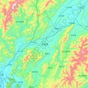
Name: Xing'an County topographic map, elevation, terrain.
Location: Xing'an County, Guilin, Guangxi, China (25.30987 110.23555 25.91704 110.93081)
Average elevation: 548 m
Minimum elevation: 151 m
Maximum elevation: 2,093 m
Thank you for supporting this site ❤️
Make a donation
Make a donation
Other topographic maps
Click on a map to view its topography, its elevation and its terrain.