Geolocate

Miranda State topographic map

Interactive map

Click on the map to display elevation.

Miranda State

The hydrography of Miranda State is characterized by the short course and low flow of its rivers, with the exception of Tuy. This characteristic, combined with the settlement of the largest mass of population in the country, gives its rivers great significance as sources of water for urban consumption. The Tuy River, with a length of 250 km, rises at an altitude of 2 100 m, on the southern flank of the Litoral mountain range, flows eastwards through the Abra de Tácata to the Tuy and Barlovento valleys, and flows into the Caribbean Sea through the Paparo mouth. The El Jarillo River and the Aguas Frías and La Negra streams, tributaries of the Tuy on the left bank, have been dammed, near the Teques, in the Agua Fría reservoir, while the Ocumare, was dammed near Ocumare del Tuy, in the Ocumarito reservoir. The best known tributary is the Guaire River. On the right bank, the Tuy receives the Taguaza, Taguacita and Cuira rivers. Other important rivers are the Guarenas, Rio Grande or Caucagua, Capaya, El Guapo, Pacairigua, El Curiepe and Cúpira.

About this map

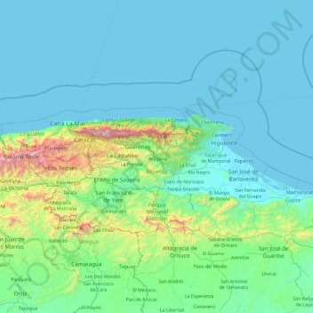
Name: Miranda State topographic map, elevation, terrain.

Location: Miranda State, Venezuela (9.93459 -67.22042 10.87641 -65.42090)

Average elevation: 244 m

Minimum elevation: 0 m

Maximum elevation: 2,639 m

Other topographic maps

Click on a map to view its topography, its elevation and its terrain.

Puerto La Cruz

Venezuela > Anzoategui State > Municipio Sotillo

The city of Puerto La Cruz is located on the southern shore of the Caribbean. The elevation of the city varies between 767 and 64 metres (2,516 and 210 ft). The city position is at Latitude 10° 13' N and Longitude 64° 37' W. Typical temperatures vary between 25–28 °C (77–82 °F). Borders are represented…

Average elevation: 89 m

Valencia

Venezuela > Carabobo State > Municipio Valencia

The elevation of the city is 520 metres (1,710 feet).

Average elevation: 600 m

Lara State

Venezuela

Lara's topography consist of high plains and low, broken hills, with a relatively hot and dry climate. Lara depression is located at altitudes between 1,600 and 2,600 ft (487 to 792 m). Among the landscapes of moderate height, the pressures of Carora, Barquisimeto and Yaracuy stand out, while the Sierra de…

Average elevation: 650 m

Táriba

Venezuela > Tachira State > Municipio Cárdenas

Average elevation: 1,071 m

Petare

Venezuela > Sucre State > Municipio Sucre

Average elevation: 83 m

Caracas

Venezuela > Miranda State > Municipio Baruta

Caracas is contained entirely within a valley of the Venezuelan Central Range, and is separated from the Caribbean coast by a roughly 15-kilometer (9 mi) expanse of El Ávila National Park. The valley is relatively small and quite irregular, and the altitude varies from between 870 and 1,043 meters (2,854 and…

Average elevation: 735 m

Falcón

Venezuela

Average elevation: 209 m

Zulia

Venezuela

Average elevation: 381 m

Aragua

Venezuela

Average elevation: 134 m

Bolívar

Venezuela > Bolívar

Average elevation: 412 m

Lara

Venezuela > Lara

Average elevation: 275 m

Apure

Venezuela > Apure

Average elevation: 239 m

La Corona Glacier

Venezuela > Mérida > Mérida

Average elevation: 4,387 m

Lake Maracaibo

Venezuela > Zulia > Tía Juana

Average elevation: 148 m

Río Orinoco

Venezuela > Delta Amacuro State

Average elevation: 114 m

Tacarigua

Venezuela > Carabobo > Tacarigua

Average elevation: 461 m

Humboldt

Venezuela > Mérida > Mérida

Average elevation: 4,371 m

Isla Margarita

Venezuela > Nueva Esparta

Average elevation: 12 m

Municipio Santos Marquina

Venezuela

Average elevation: 2,910 m