
Make a donation
Forgue topographic map
Click on the map to display elevation.
Make a donation
About this map
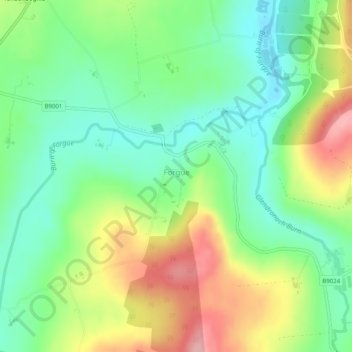
Name: Forgue topographic map, elevation, terrain.
Location: Forgue, Aberdeenshire, Scotland, United Kingdom (57.48651 -2.65651 57.49486 -2.64591)
Average elevation: 113 m
Minimum elevation: 61 m
Maximum elevation: 195 m
Make a donation
Other topographic maps
Click on a map to view its topography, its elevation and its terrain.
Ben Macdui
United Kingdom > Scotland > Aberdeenshire
Ben Macdui (Scottish Gaelic: Beinn Mac Duibh, meaning "Mac Duff's Hill") is the second-highest mountain in Scotland (and all of the British Isles) after Ben Nevis, and the highest in the Cairngorm Mountains and the wider Cairngorms National Park. The summit elevation is 1,309 metres (4,295 feet) AMSL. Ben…
Average elevation: 1,031 m
Braemar
United Kingdom > Scotland > Aberdeenshire
Braemar /breɪˈmɑːr/ (listen) is a village in Aberdeenshire, Scotland, around 58 miles (93 km) west of Aberdeen in the Highlands. It is the closest significantly-sized settlement to the upper course of the River Dee sitting at an elevation of 339 metres (1,112 ft).
Average elevation: 445 m
Make a donation