
Thank you for supporting this site ❤️
Make a donation
Make a donation
Bumula topographic map
Click on the map to display elevation.
Thank you for supporting this site ❤️
Make a donation
Make a donation
About this map
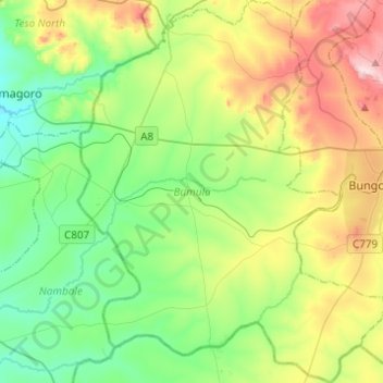
Name: Bumula topographic map, elevation, terrain.
Location: Bumula, Bungoma County, Kenya (0.44366 34.36915 0.68898 34.56725)
Average elevation: 1,326 m
Minimum elevation: 1,166 m
Maximum elevation: 1,661 m
Thank you for supporting this site ❤️
Make a donation
Make a donation
Other topographic maps
Click on a map to view its topography, its elevation and its terrain.