Geolocate

Kota Belud topographic map

Interactive map

Click on the map to display elevation.

About this map

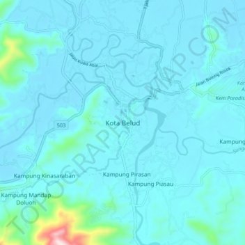
Name: Kota Belud topographic map, elevation, terrain.

Location: Kota Belud, Sabah, 89158, Malaysia (6.30976 116.38929 6.38976 116.46929)

Average elevation: 41 m

Minimum elevation: 1 m

Maximum elevation: 518 m

Other topographic maps

Click on a map to view its topography, its elevation and its terrain.

Mount Kinabalu

Malaysia > Sabah > Ranau

Mount Kinabalu (Dusun: Gayo Ngaran or Nulu Nabalu, Malay: Gunung Kinabalu) is the highest mountain in Borneo and Malaysia. With an elevation of 4,095 metres (13,435 ft), it is the third-highest peak of an island on Earth, the 28th highest peak in Southeast Asia, and 20th most prominent mountain in the world.…

Average elevation: 3,567 m

Kundasang

Malaysia > Sabah > Ranau

Average elevation: 1,279 m

Pekan Nabalu

Malaysia > Sabah > Kota Belud

Average elevation: 761 m

Genting

Malaysia > Sabah > Sandakan District

Average elevation: 26 m

Keningau

Malaysia > Sabah

Average elevation: 520 m

Tambunan

Malaysia > Sabah > Tambunan

Tambunan (Malay: Pekan Tambunan) is the capital of the Tambunan District in the Interior Division of Sabah, Malaysia. Its population was estimated to be around 35,667 in 2010. It is located 80 kilometres east of the state capital, Kota Kinabalu (to which is connected by the Kota Kinabalu-Tambunan-Keningau…

Average elevation: 697 m

Kota Kinabalu

Malaysia > Sabah

Average elevation: 86 m

Pulau Mantanani Besar

Malaysia > Sabah

Average elevation: 2 m