
Bicester topographic map
Click on the map to display elevation.
Bicester
Bicester has expanded rapidly in recent generations due to the town's picturesque historical town centre, garden town layout, independent and high-street shops, restaurants, as well as a rail connection to Oxford. It also boasts imminent connection to Cambridge, as well as rail links to Birmingham and London. It is similarly proximate to Brackley, Buckingham, Banbury, Milton Keynes, and Aylesbury by road. A considerable volume of high quality and environmentally friendly housing stock has been constructed, in particular at the Elmsbrook eco-town and the self-built homes at Graven Hill. Its flat topography and compact size is suited to walking and cycling, which, together with an active cycle campaign, has attracted a significant focus on developing improved active travel infrastructure. This includes the majority of a £14 million central government award to Oxfordshire County Council for the purpose of developing safer walking and cycling schemes.
About this map
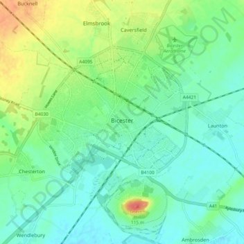
Name: Bicester topographic map, elevation, terrain.
Average elevation: 77 m
Minimum elevation: 60 m
Maximum elevation: 114 m
Other topographic maps
Click on a map to view its topography, its elevation and its terrain.
Tusmore
United Kingdom > England > Oxfordshire > Cherwell District > Hardwick
Average elevation: 119 m