
Thank you for supporting this site ❤️
Make a donation
Make a donation
Cumberland County topographic map
Click on the map to display elevation.
Thank you for supporting this site ❤️
Make a donation
Make a donation
About this map
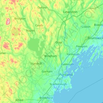
Name: Cumberland County topographic map, elevation, terrain.
Location: Cumberland County, Maine, United States (43.46688 -70.86662 44.17105 -69.85703)
Average elevation: 85 m
Minimum elevation: -5 m
Maximum elevation: 589 m
Thank you for supporting this site ❤️
Make a donation
Make a donation
Other topographic maps
Click on a map to view its topography, its elevation and its terrain.
Spring Island
United States > Maine > Penobscot County > T4 Indian Purchase Township
Average elevation: 151 m
Eastern Bay
United States > Maine > Hancock County > Bar Harbor > Salsbury Cove
Average elevation: 9 m
Thank you for supporting this site ❤️
Make a donation
Make a donation