
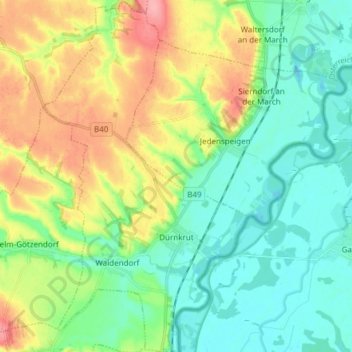
Gemeinde Dürnkrut topographic map
Interactive map
Click on the map to display elevation.
About this map
Name: Gemeinde Dürnkrut topographic map, elevation, terrain.
Average elevation: 180 m
Minimum elevation: 143 m
Maximum elevation: 233 m
Other topographic maps
Click on a map to view its topography, its elevation and its terrain.
Raggendorf
Österreich > Niederösterreich > Bezirk Gänserndorf > Matzen-Raggendorf
Raggendorf, Matzen-Raggendorf, Bezirk Gänserndorf, Niederösterreich, 2215, Österreich
Average elevation: 185 m
Spannberg
Österreich > Niederösterreich > Bezirk Gänserndorf
Spannberg, Bezirk Gänserndorf, Niederösterreich, 2244, Österreich
Average elevation: 200 m
Klein-Harras
Österreich > Niederösterreich > Bezirk Gänserndorf > Matzen-Raggendorf
Klein-Harras, Matzen-Raggendorf, Bezirk Gänserndorf, Niederösterreich, 2223, Österreich
Average elevation: 209 m
Parbasdorf
Österreich > Niederösterreich > Bezirk Gänserndorf
Parbasdorf, Bezirk Gänserndorf, Niederösterreich, 2232, Österreich
Average elevation: 158 m
Maustrenk
Österreich > Niederösterreich > Bezirk Gänserndorf > Zistersdorf
Maustrenk, Zistersdorf, Bezirk Gänserndorf, Niederösterreich, 2225, Österreich
Average elevation: 240 m
Auersthal
Österreich > Niederösterreich > Bezirk Gänserndorf > Gemeinde Auersthal
Auersthal, Gemeinde Auersthal, Bezirk Gänserndorf, Niederösterreich, 2214, Österreich
Average elevation: 181 m
Gemeinde Weiden an der March
Österreich > Niederösterreich > Bezirk Gänserndorf
Gemeinde Weiden an der March, Bezirk Gänserndorf, Niederösterreich, 2295, Österreich
Average elevation: 148 m
Markthof
Österreich > Niederösterreich > Bezirk Gänserndorf > Gemeinde Engelhartstetten
Markthof, Gemeinde Engelhartstetten, Bezirk Gänserndorf, Niederösterreich, 2292, Österreich
Average elevation: 158 m
Gemeinde Velm-Götzendorf
Österreich > Niederösterreich > Bezirk Gänserndorf
Gemeinde Velm-Götzendorf, Bezirk Gänserndorf, Niederösterreich, 2245, Österreich
Average elevation: 188 m
Gemeinde Gänserndorf
Österreich > Niederösterreich > Bezirk Gänserndorf
Gemeinde Gänserndorf, Bezirk Gänserndorf, Niederösterreich, 2230, Österreich
Average elevation: 158 m
Lobau
Österreich > Niederösterreich > Bezirk Gänserndorf > Gemeinde Groß-Enzersdorf
Lobau, Gemeinde Groß-Enzersdorf, Bezirk Gänserndorf, Niederösterreich, 2301, Österreich
Average elevation: 158 m
Gemeinde Aderklaa
Österreich > Niederösterreich > Bezirk Gänserndorf
Gemeinde Aderklaa, Bezirk Gänserndorf, Niederösterreich, 2232, Österreich
Average elevation: 158 m
Gänserndorf
Österreich > Niederösterreich > Bezirk Gänserndorf > Gemeinde Gänserndorf
Gänserndorf, Gemeinde Gänserndorf, Bezirk Gänserndorf, Niederösterreich, 2230, Österreich
Average elevation: 343 m
Zwerndorf
Österreich > Niederösterreich > Bezirk Gänserndorf > Gemeinde Weiden an der March > Zwerndorf
Zwerndorf, Gemeinde Weiden an der March, Bezirk Gänserndorf, Niederösterreich, 2295, Österreich
Average elevation: 146 m
March (Nebeng.) [bei Hohenau] II
Österreich > Niederösterreich > Bezirk Gänserndorf > Gemeinde Hohenau an der March
March (Nebeng.) [bei Hohenau] II, Gemeinde Hohenau an der March, Bezirk Gänserndorf, Niederösterreich, 2273, Österreich
Average elevation: 154 m
Leopoldsdorf im Marchfelde
Österreich > Niederösterreich > Bezirk Gänserndorf > Gemeinde Leopoldsdorf im Marchfelde > Leopoldsdorf im Marchfelde
Leopoldsdorf im Marchfelde, Gemeinde Leopoldsdorf im Marchfelde, Bezirk Gänserndorf, Niederösterreich, 2285, Österreich
Average elevation: 150 m
Kollnbrunn
Österreich > Niederösterreich > Bezirk Gänserndorf > Gemeinde Bad Pirawarth > Kollnbrunn
Kollnbrunn, Gemeinde Bad Pirawarth, Bezirk Gänserndorf, Niederösterreich, 2222, Österreich
Average elevation: 211 m
Strasshof an der Nordbahn
Österreich > Niederösterreich > Bezirk Gänserndorf > Gemeinde Strasshof an der Nordbahn
Strasshof an der Nordbahn, Gemeinde Strasshof an der Nordbahn, Bezirk Gänserndorf, Niederösterreich, 2231, Österreich
Average elevation: 163 m
Dürnkrut
Österreich > Niederösterreich > Bezirk Gänserndorf > Dürnkrut
Dürnkrut, Gemeinde Dürnkrut, Bezirk Gänserndorf, Niederösterreich, 2263, Österreich
Average elevation: 160 m
Gemeinde Bad Pirawarth
Österreich > Niederösterreich > Bezirk Gänserndorf > Gemeinde Bad Pirawarth
Gemeinde Bad Pirawarth, Bezirk Gänserndorf, Niederösterreich, 2222, Österreich
Average elevation: 214 m
Groß-Schweinbarth
Österreich > Niederösterreich > Bezirk Gänserndorf > Gemeinde Groß-Schweinbarth
Groß-Schweinbarth, Gemeinde Groß-Schweinbarth, Bezirk Gänserndorf, Niederösterreich, 2221, Österreich
Average elevation: 199 m