
Redfield topographic map
Interactive map
Click on the map to display elevation.
About this map
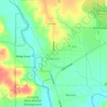
Name: Redfield topographic map, elevation, terrain.
Location: Redfield, Dallas County, Iowa, United States (41.58151 -94.20907 41.59999 -94.18018)
Average elevation: 298 m
Minimum elevation: 274 m
Maximum elevation: 335 m
Other topographic maps
Click on a map to view its topography, its elevation and its terrain.
Adel
United States > Iowa > Dallas County
Adel, Dallas County, Iowa, United States
Average elevation: 292 m
Waukee
United States > Iowa > Dallas County
Waukee, Dallas County, Iowa, 50263, United States
Average elevation: 298 m
Dexter
United States > Iowa > Dallas County
Dexter, Dallas County, Iowa, United States
Average elevation: 343 m