
Minalabac topographic map
Click on the map to display elevation.
About this map
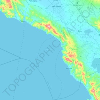
Name: Minalabac topographic map, elevation, terrain.
Location: Minalabac, Camarines Sur, Bicol Region, 4414, Philippines (13.18748 123.09612 13.59481 123.25356)
Average elevation: 33 m
Minimum elevation: 0 m
Maximum elevation: 479 m
Other topographic maps
Click on a map to view its topography, its elevation and its terrain.
Mount Isarog
Philippines > Camarines Sur > Lugsad
Mount Isarog is an active stratovolcano located in the province of Camarines Sur, Philippines, on the island of Luzon. The mountain has active fumaroles and hot springs. It has an elevation of 2,011.6 m (6,600 ft) above mean sea level.
Average elevation: 671 m
Buhi
Buhi has generally mountainous and hilly surface, with 50% of its area having a slope of around 25%. The Poblacion located on the south shore of Lake Buhi, has gently rolling topography.
Average elevation: 161 m