
Thank you for supporting this site ❤️
Make a donation
Make a donation
Jâlons topographic map
Click on the map to display elevation.
Thank you for supporting this site ❤️
Make a donation
Make a donation
Jâlons
Le territoire communal s'étend sur 10,35 km2. L'altitude varie entre 72 m, en bord de Marne, et 93 m, dans les champs au sud du village.
Thank you for supporting this site ❤️
Make a donation
Make a donation
About this map
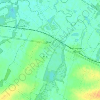
Name: Jâlons topographic map, elevation, terrain.
Average elevation: 79 m
Minimum elevation: 70 m
Maximum elevation: 100 m
Thank you for supporting this site ❤️
Make a donation
Make a donation
Other topographic maps
Click on a map to view its topography, its elevation and its terrain.