
Thank you for supporting this site ❤️
Make a donation
Make a donation
Earl topographic map
Click on the map to display elevation.
Thank you for supporting this site ❤️
Make a donation
Make a donation
About this map
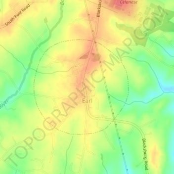
Name: Earl topographic map, elevation, terrain.
Location: Earl, Cleveland County, North Carolina, United States (35.18822 -81.54331 35.20297 -81.52533)
Average elevation: 241 m
Minimum elevation: 207 m
Maximum elevation: 269 m
Thank you for supporting this site ❤️
Make a donation
Make a donation
Other topographic maps
Click on a map to view its topography, its elevation and its terrain.
Thank you for supporting this site ❤️
Make a donation
Make a donation
Osborne Apartments
United States > North Carolina > Cleveland County > Shelby
Average elevation: 256 m