
Make a donation
Balite I topographic map
Click on the map to display elevation.
Make a donation
About this map
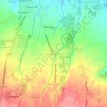
Name: Balite I topographic map, elevation, terrain.
Location: Balite I, Silang, Cavite, Calabarzon, 4118, Philippines (14.17955 120.96150 14.21955 121.00150)
Average elevation: 361 m
Minimum elevation: 310 m
Maximum elevation: 414 m
Make a donation
Other topographic maps
Click on a map to view its topography, its elevation and its terrain.
Caballo Island
Philippines > Cavite > Cavite City
Caballo Island (which means "Horse Island" in Spanish) is a bluff, rocky island located at the entrance to Manila Bay in the Philippines. It is about 1.2 km (0.75 mi) long with the highest elevation at 381 feet high. Caballo, along with the larger Corregidor (2 km to the north), divides the entrance to the bay…
Average elevation: 0 m
Make a donation
Make a donation
Tagaytay Heights
Philippines > Cavite > Tagaytay > Kaybagal East > Tagaytay Heights
Average elevation: 612 m
Make a donation
Carmona
The topography of Carmona is generally flat to strongly rolling or sloping, partly lowland and partly hill. Carmona is divided into four physiographical areas: the lowest lowland area, the lowland area, the central hilly area and the upland mountainous area.
Average elevation: 56 m
Make a donation
Make a donation