
Columbia County topographic map
Interactive map
Click on the map to display elevation.
About this map
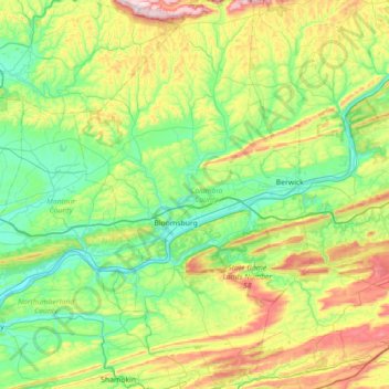
Name: Columbia County topographic map, elevation, terrain.
Location: Columbia County, Pennsylvania, United States of America (40.77548 -76.64185 41.31092 -76.20782)
Average elevation: 306 m
Minimum elevation: 126 m
Maximum elevation: 779 m
Other topographic maps
Click on a map to view its topography, its elevation and its terrain.
South Mountain Park
United States of America > Pennsylvania > Lower Saucon Township > Star Village
Average elevation: 169 m
Clover Hill
United States of America > Pennsylvania > West Pike Run Township > Clover Hill
Average elevation: 347 m