
Morong topographic map
Click on the map to display elevation.
About this map
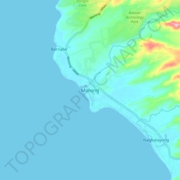
Name: Morong topographic map, elevation, terrain.
Location: Morong, Bataan, Central Luzon, 2108, Philippines (14.63800 120.22526 14.71800 120.30526)
Average elevation: 20 m
Minimum elevation: 0 m
Maximum elevation: 202 m
Other topographic maps
Click on a map to view its topography, its elevation and its terrain.