
Papanui-Innes Community topographic map
Click on the map to display elevation.
About this map
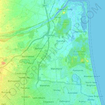
Name: Papanui-Innes Community topographic map, elevation, terrain.
Average elevation: 8 m
Minimum elevation: -8 m
Maximum elevation: 35 m
Christchurch City trails, hiking, mountain biking, running and outdoor activities
Other topographic maps
Click on a map to view its topography, its elevation and its terrain.
Lyttelton
New Zealand > Canterbury > Christchurch City > Banks Peninsula Community
Average elevation: 99 m
Governors Bay
New Zealand > Canterbury > Christchurch City > Banks Peninsula Community
Average elevation: 167 m
Birdlings Flat
New Zealand > Canterbury > Christchurch City > Banks Peninsula Community
Average elevation: 15 m
Banks Peninsula
New Zealand > Canterbury > Christchurch City > Banks Peninsula Community > Pigeon Bay
Average elevation: 277 m
Okuti Valley
New Zealand > Canterbury > Christchurch City > Banks Peninsula Community
Average elevation: 288 m
Little River
New Zealand > Canterbury > Christchurch City > Banks Peninsula Community > Little River
Average elevation: 150 m
Port hills
New Zealand > Canterbury > Christchurch City > Linwood-Central-Heathcote Community
Average elevation: 246 m
Little Akaloa
New Zealand > Canterbury > Christchurch City > Banks Peninsula Community
Average elevation: 215 m
Purple Peak Saddle
New Zealand > Canterbury > Christchurch City > Banks Peninsula Community
Average elevation: 479 m
Bossu
New Zealand > Canterbury > Christchurch City > Banks Peninsula Community
Average elevation: 409 m
Ōhinetahi
New Zealand > Canterbury > Christchurch City > Banks Peninsula Community > Governors Bay
Average elevation: 113 m
Giant Totara tree
New Zealand > Canterbury > Christchurch City > Banks Peninsula Community
Average elevation: 382 m