
Thank you for supporting this site ❤️
Make a donation
Make a donation
Nara Park topographic map
Click on the map to display elevation.
Thank you for supporting this site ❤️
Make a donation
Make a donation
About this map
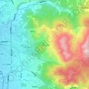
Name: Nara Park topographic map, elevation, terrain.
Location: Nara Park, Nara, Nara Prefecture, Japan (34.67334 135.82913 34.69279 135.88182)
Average elevation: 227 m
Minimum elevation: 78 m
Maximum elevation: 513 m
Thank you for supporting this site ❤️
Make a donation
Make a donation