
Wye Valley topographic map
Click on the map to display elevation.
About this map
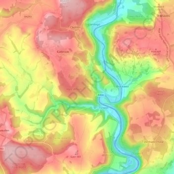
Name: Wye Valley topographic map, elevation, terrain.
Location: Wye Valley, Monmouthshire, Wales, United Kingdom (51.66975 -2.72328 51.74396 -2.65684)
Average elevation: 167 m
Minimum elevation: -3 m
Maximum elevation: 301 m
Other topographic maps
Click on a map to view its topography, its elevation and its terrain.
Usk
United Kingdom > Wales > Monmouthshire
The origin of the Welsh name Brynbuga (Welsh: [brɨ̞nˈbɨ̞ga]) is less certain. The local Brythonic name adopted into Latin as Burrium or Burrio was recorded as Brunebegy and Burenbegie in the 15th century. The modern name is likely an example of the linguistic metathesis common in Welsh Topography. Folk…
Average elevation: 66 m
New Castle
United Kingdom > Wales > Monmouthshire > Llangattock Vibon Avel > Newcastle
Average elevation: 121 m