
Provincia de Santiago topographic map
Interactive map
Click on the map to display elevation.
Provincia de Santiago
Most of the province is made up of an extremely fertile, level prairie that the locals call la Depresión intermedia (Intermediate Depression). The terrain is known for its low elevation in relation to sea level and for being surrounded by hills, as well as emergent so-called island hills, such as Santa Lucía (an ancient extinct volcano), Blanco, and Renca, present today in the city of Santiago.
About this map
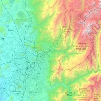
Name: Provincia de Santiago topographic map, elevation, terrain.
Location: Provincia de Santiago, Santiago Metropolitan Region, Chile (-33.62747 -70.95522 -33.09694 -70.17615)
Average elevation: 1,701 m
Minimum elevation: 360 m
Maximum elevation: 5,538 m
Other topographic maps
Click on a map to view its topography, its elevation and its terrain.
Chicureo
Chile > Santiago Metropolitan Region > Provincia de Chacabuco > Colina
Average elevation: 711 m
Montenegro
Chile > Santiago Metropolitan Region > Provincia de Chacabuco > Tiltil
Average elevation: 836 m
Rinconada
Chile > Santiago Metropolitan Region > Provincia de Talagante > El Monte > El Paico Alto
Average elevation: 445 m