
Make a donation
San Jose del Monte topographic map
Click on the map to display elevation.
Make a donation
San Jose del Monte
The elevation of the city ranges from approximately 40 to 900 meters (130 to 2,950 ft) above sea level; the relief transitions from warm lowland to cool upland as one goes eastward. This is because the city is part of the Sierra Madre mountain range. Plains and river valley flats characterize the western and southwestern quadrant. The central portion and much of its eastern section are made up of undulating hills with low relief. High relief areas moderate slopes best describe its extreme eastern and northwestern quadrant. Slopes of 3%-8% are extensively found in the city, particularly on the western half. Slopes of 30%-50% comprise the smallest portion of the total land area.
Make a donation
About this map
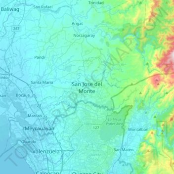
Name: San Jose del Monte topographic map, elevation, terrain.
Average elevation: 106 m
Minimum elevation: -3 m
Maximum elevation: 981 m
Make a donation
Other topographic maps
Click on a map to view its topography, its elevation and its terrain.
Make a donation
Make a donation
Make a donation
Doña Remedios Trinidad
List of highest peaks in D.R.T by elevation.
Average elevation: 172 m