
City of Sarajevo topographic map
Interactive map
Click on the map to display elevation.
About this map
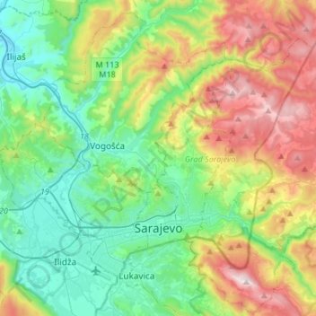
Name: City of Sarajevo topographic map, elevation, terrain.
Average elevation: 810 m
Minimum elevation: 437 m
Maximum elevation: 1,604 m
Other topographic maps
Click on a map to view its topography, its elevation and its terrain.
Goražde
Bosnia and Herzegovina > Federation of Bosnia and Herzegovina > City of Goražde
Goražde, City of Goražde, Bosnian-Podrinje Canton Goražde, Federation of Bosnia and Herzegovina, 73000, Bosnia and Herzegovina
Average elevation: 576 m
Bjelašnica
Bosnia and Herzegovina > Federation of Bosnia and Herzegovina > City of Istočno Sarajevo
Bjelašnica, City of Istočno Sarajevo, Sarajevo Canton, Federation of Bosnia and Herzegovina, 71220, Bosnia and Herzegovina
Average elevation: 1,101 m