Geolocate
👉 Easily get elevation data in JSON, GeoTIFF and KML formats using Elevation API
Thank you for supporting this site ❤️
Make a donation

Basdiot topographic map

Click on the map to display elevation.

👉 Easily get elevation data in JSON, GeoTIFF and KML formats using Elevation API
Thank you for supporting this site ❤️
Make a donation

About this map

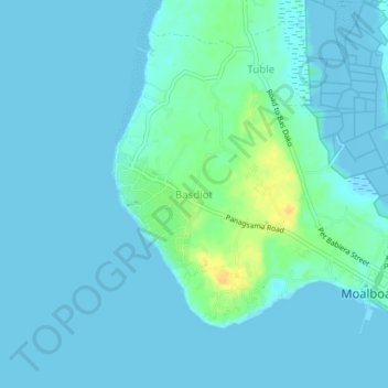
Name: Basdiot topographic map, elevation, terrain.

Location: Basdiot, Cebu, Central Visayas, 6032, Philippines (9.92744 123.35396 9.96744 123.39396)

Average elevation: 5 m

Minimum elevation: -1 m

Maximum elevation: 27 m

Other topographic maps

Click on a map to view its topography, its elevation and its terrain.

Bulacao River

Philippines > Cebu > Talisay

Average elevation: 3 m

Lauis Ledge Lighthouse

Philippines > Cebu > Talisay

Average elevation: 0 m

Gilutongan Island

Philippines > Cebu > Cordova > Gilutongan

Average elevation: 0 m

Logon

Philippines > Cebu

Average elevation: 1 m