
Thank you for supporting this site ❤️
Make a donation
Make a donation
Tigharry topographic map
Click on the map to display elevation.
Thank you for supporting this site ❤️
Make a donation
Make a donation
About this map
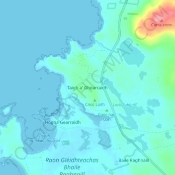
Name: Tigharry topographic map, elevation, terrain.
Location: Tigharry, Western Isles, Scotland, HS6 5DE, United Kingdom (57.59718 -7.52476 57.63718 -7.48476)
Average elevation: 11 m
Minimum elevation: -1 m
Maximum elevation: 112 m
Thank you for supporting this site ❤️
Make a donation
Make a donation
Other topographic maps
Click on a map to view its topography, its elevation and its terrain.
Àird
United Kingdom > Scotland > Western Isles
There is a dense cluster of lochs across almost the entire island, and almost all of the island is below 20 metres (70 feet) in elevation.
Average elevation: 5 m