
Bluff Hill topographic map
Interactive map
Click on the map to display elevation.
About this map
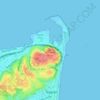
Name: Bluff Hill topographic map, elevation, terrain.
Location: Bluff Hill, Napier, Hawke's Bay, 4001, New Zealand (-39.47894 176.91724 -39.47884 176.91734)
Average elevation: 14 m
Minimum elevation: -1 m
Maximum elevation: 100 m
Hawke's Bay trails, hiking, mountain biking, running and outdoor activities
Other topographic maps
Click on a map to view its topography, its elevation and its terrain.