Geolocate

Kassena-Nankana West District topographic map

Interactive map

Click on the map to display elevation.

Kassena-Nankana West District topographic map, elevation, terrain

Kassena-Nankana West District topographic map, elevation, terrain

About this map

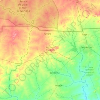
Name: Kassena-Nankana West District topographic map, elevation, terrain.

Location: Kassena-Nankana West District, Upper East Region, Ghana (10.72645 -1.52894 11.02103 -0.90503)

Average elevation: 233 m

Minimum elevation: 132 m

Maximum elevation: 431 m

Other topographic maps

Click on a map to view its topography, its elevation and its terrain.

Eastern Region

Ghana

Average elevation: 165 m

Central Region

Ghana

Average elevation: 114 m

Greater Accra Region

Ghana

Average elevation: 62 m

Western Region

Ghana

Average elevation: 86 m

Northern Region

Ghana

Average elevation: 149 m

Upper East Region

Ghana

Average elevation: 214 m

Ashanti Region

Ghana

Average elevation: 208 m

Tono Dam

Ghana > Upper East Region

Average elevation: 176 m