
Grand Est topographic map
Click on the map to display elevation.
About this map
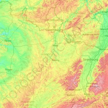
Name: Grand Est topographic map, elevation, terrain.
Location: Grand Est, Metropolitan France, France (47.42034 3.38364 50.16932 8.23285)
Average elevation: 320 m
Minimum elevation: 52 m
Maximum elevation: 1,480 m
Other topographic maps
Click on a map to view its topography, its elevation and its terrain.
Basse-Bretagne
France > Centre-Val de Loire > Indre-et-Loire > Château-la-Vallière
Average elevation: 89 m
Barricata
France > Nouvelle-Aquitaine > Pyrénées-Atlantiques > Aussurucq > Etxakokua
Average elevation: 260 m
La Patte au Loup
France > Centre-Val de Loire > Indre-et-Loire > Chouzé-sur-Loire
Average elevation: 31 m