
Make a donation
West Kalimantan topographic map
Click on the map to display elevation.
Make a donation
West Kalimantan
Influenced by the vast lowlands, the heights of the mountains are relatively low as well as non-volcanically active. The highest mountain is Mount Baturaya in Serawai District of Sintang Regency which has an altitude of 2,278 metres above sea level, far lower than Mount Semeru (East Java, 3,676 metres) or Mount Kerinci (Jambi, 3,805 metres).
Make a donation
About this map
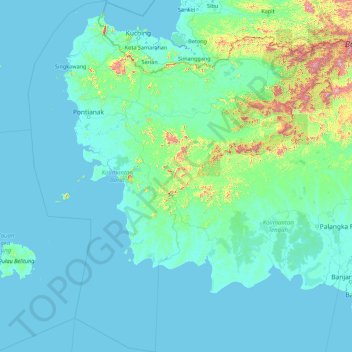
Name: West Kalimantan topographic map, elevation, terrain.
Location: West Kalimantan, Kalimantan, Indonesia (-4.71531 108.13865 2.31472 114.20543)
Average elevation: 92 m
Minimum elevation: -4 m
Maximum elevation: 2,127 m
Make a donation
Other topographic maps
Click on a map to view its topography, its elevation and its terrain.
Bandung
Indonesia > West Java > Bandung
Bandung, the capital of West Java province, located about 180 kilometres (110 mi) southeast of Jakarta, is the third-largest city in Indonesia. Its elevation is 768 metres (2,520 ft) above sea level and is surrounded by up to 2,400 metres (7,900 feet) high Late Tertiary and Quaternary volcanic terrain. The 400…
Average elevation: 879 m
Make a donation
Make a donation
Make a donation
Make a donation
Make a donation
Make a donation
Make a donation
East Java
East Java has a tropical monsoon and savanna climate at lower elevation and subtropical at higher elevation. Compared with the western part of Java Island, East Java in general has less rainfall. Average rainfall is 1,900 mm per year, with a rainy season during the 100 days. The average temperature ranges…
Average elevation: 66 m
Make a donation
Make a donation
Make a donation
Make a donation
Make a donation