
Tsoundzou 1 topographic map
Interactive map
Click on the map to display elevation.
About this map
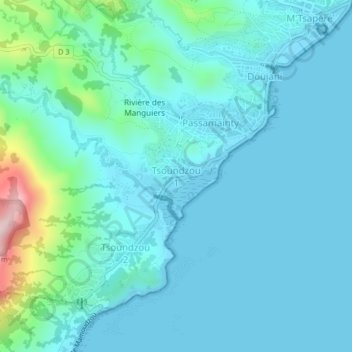
Name: Tsoundzou 1 topographic map, elevation, terrain.
Location: Tsoundzou 1, Mamoudzou, Mayotte, 97605, France (-12.82724 45.18515 -12.78724 45.22515)
Average elevation: 52 m
Minimum elevation: -1 m
Maximum elevation: 366 m
Other topographic maps
Click on a map to view its topography, its elevation and its terrain.
Parc de la Pointe Mahabou
Parc de la Pointe Mahabou, Doujani, Mamoudzou, Mayotte, 97600, France
Average elevation: 6 m
Îlot Mbouzi
Îlot Mbouzi, Mamoudzou, Mayotte, 97600, France
Average elevation: 5 m