
Krujë topographic map
Interactive map
Click on the map to display elevation.
About this map
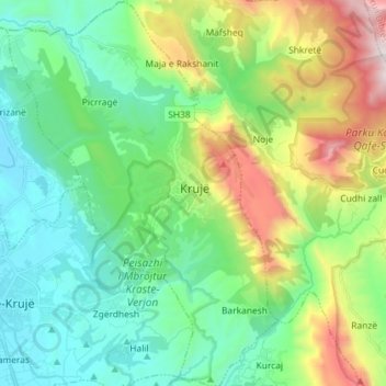
Name: Krujë topographic map, elevation, terrain.
Location: Krujë, Kruje, Durrës County, Northern Albania, 1501, Albania (41.45549 19.72239 41.56333 19.82417)
Average elevation: 397 m
Minimum elevation: -1 m
Maximum elevation: 1,448 m
Krujë is found at an altitude of 600 m (1,969 ft) on the foot of Mount Krujë (Albanian: Mali i Krujës), while south and west of the town is found the plain of the Ishëm River. The town is located in the northern part of the outer Albanides tectonic unit, which consists of anticlines of Mesozoic carbonate platforms. The administrative centre of the municipality is the town of Krujë, but it also includes the villages of Barkanesh, Brre and Picerragë. The closest cities to Krujë are Tiranë and Durrës at a distance of 20 and 37 km respectively.