
Thank you for supporting this site ❤️
Make a donation
Make a donation
Ellingstring topographic map
Click on the map to display elevation.
Thank you for supporting this site ❤️
Make a donation
Make a donation
About this map
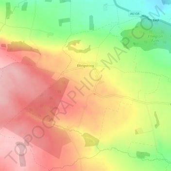
Name: Ellingstring topographic map, elevation, terrain.
Average elevation: 211 m
Minimum elevation: 107 m
Maximum elevation: 289 m
Thank you for supporting this site ❤️
Make a donation
Make a donation
Other topographic maps
Click on a map to view its topography, its elevation and its terrain.
Thank you for supporting this site ❤️
Make a donation
Make a donation
Thank you for supporting this site ❤️
Make a donation
Make a donation
Thank you for supporting this site ❤️
Make a donation
Make a donation
Thank you for supporting this site ❤️
Make a donation
Make a donation
Thornydale Laithe
United Kingdom > England > North Yorkshire > Craven > Calton
Average elevation: 179 m
Thank you for supporting this site ❤️
Make a donation
Make a donation
Thank you for supporting this site ❤️
Make a donation
Make a donation
Milby Cut
United Kingdom > England > North Yorkshire > Harrogate > Aldborough > Milby
Average elevation: 20 m