
Make a donation
Somerville topographic map
Click on the map to display elevation.
Make a donation
About this map
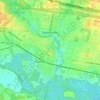
Name: Somerville topographic map, elevation, terrain.
Location: Somerville, Somerset County, New Jersey, United States (40.55609 -74.62638 40.58170 -74.58626)
Average elevation: 21 m
Minimum elevation: 7 m
Maximum elevation: 40 m
Make a donation
Other topographic maps
Click on a map to view its topography, its elevation and its terrain.
Second Watchung Mountain
United States > New Jersey > Somerset County > Bridgewater Township
Average elevation: 110 m
Blackwells Mills
United States > New Jersey > Somerset County > Franklin Township
Average elevation: 24 m
Make a donation
Bradley Gardens
United States > New Jersey > Somerset County > Bridgewater Township
Average elevation: 28 m
Franklin Park Natural Area
United States > New Jersey > Somerset County > Franklin Township
Average elevation: 40 m
First Watchung Mountain
United States > New Jersey > Somerset County > Bridgewater Township
Average elevation: 55 m
Make a donation
Green Brook
United States > New Jersey > Somerset County > Green Brook Township
Average elevation: 43 m
Make a donation
Make a donation
Green Knoll
United States > New Jersey > Somerset County > Bridgewater Township
Average elevation: 63 m
Make a donation