
Xaltocan topographic map
Interactive map
Click on the map to display elevation.
About this map
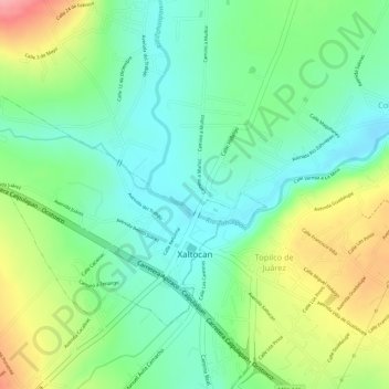
Name: Xaltocan topographic map, elevation, terrain.
Location: Xaltocan, Tlaxcala, México (19.41835 -98.22867 19.43660 -98.20414)
Average elevation: 2,476 m
Minimum elevation: 2,431 m
Maximum elevation: 2,548 m
Other topographic maps
Click on a map to view its topography, its elevation and its terrain.
San Simón Tlatlahuquitepec
San Simón Tlatlahuquitepec, Xaltocan, Tlaxcala, México
Average elevation: 2,498 m
Analco
México > Tlaxcala > Xaltocan > Santa Bárbara Acuicuizcatepec
Analco, Santa Bárbara Acuicuizcatepec, Xaltocan, Tlaxcala, México
Average elevation: 2,493 m