
Thank you for supporting this site ❤️
Make a donation
Make a donation
Thisted Municipality topographic map
Click on the map to display elevation.
Thank you for supporting this site ❤️
Make a donation
Make a donation
About this map
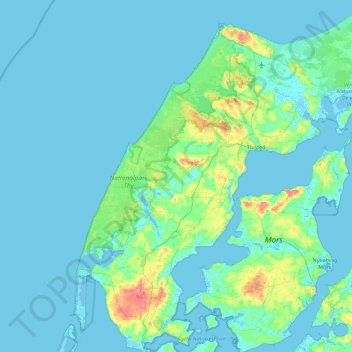
Name: Thisted Municipality topographic map, elevation, terrain.
Location: Thisted Municipality, North Denmark Region, Denmark (56.67044 8.22085 57.15895 9.09592)
Average elevation: 8 m
Minimum elevation: -5 m
Maximum elevation: 83 m
Thank you for supporting this site ❤️
Make a donation
Make a donation
Other topographic maps
Click on a map to view its topography, its elevation and its terrain.