
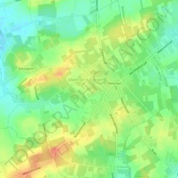
Meensel-Kiezegem topographic map
Interactive map
Click on the map to display elevation.
About this map
Name: Meensel-Kiezegem topographic map, elevation, terrain.
Average elevation: 72 m
Minimum elevation: 50 m
Maximum elevation: 97 m
Other topographic maps
Click on a map to view its topography, its elevation and its terrain.
Tielt
België > Vlaams-Brabant > Leuven > Tielt-Winge
Tielt, Tielt-Winge, Leuven, Vlaams-Brabant, België
Average elevation: 49 m
Sint-Joris-Winge
België > Vlaams-Brabant > Leuven > Tielt-Winge
Sint-Joris-Winge, Tielt-Winge, Leuven, Vlaams-Brabant, 3390, België
Average elevation: 54 m
Houwaart
België > Vlaams-Brabant > Leuven > Tielt-Winge
Houwaart, Tielt-Winge, Leuven, Vlaams-Brabant, België
Average elevation: 42 m