
Le Tour topographic map
Interactive map
Click on the map to display elevation.
About this map
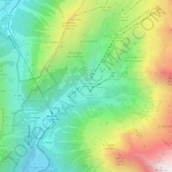
Name: Le Tour topographic map, elevation, terrain.
Average elevation: 1,811 m
Minimum elevation: 1,250 m
Maximum elevation: 2,852 m
Other topographic maps
Click on a map to view its topography, its elevation and its terrain.
les Bois
France > Auvergne-Rhône-Alpes > Haute-Savoie > Chamonix-Mont-Blanc
les Bois, Chamonix-Mont-Blanc, Bonneville, Haute-Savoie, Auvergne-Rhône-Alpes, France métropolitaine, 74400, France
Average elevation: 1,458 m