
Thank you for supporting this site ❤️
Make a donation
Make a donation
Bourail topographic map
Click on the map to display elevation.
Thank you for supporting this site ❤️
Make a donation
Make a donation
About this map
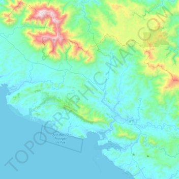
Name: Bourail topographic map, elevation, terrain.
Location: Bourail, South Province, New Caledonia, 98870, France (-21.66879 165.23101 -21.36982 165.62048)
Average elevation: 249 m
Minimum elevation: 0 m
Maximum elevation: 1,486 m
Thank you for supporting this site ❤️
Make a donation
Make a donation
Other topographic maps
Click on a map to view its topography, its elevation and its terrain.