
Thank you for supporting this site ❤️
Make a donation
Make a donation
Antioch topographic map
Click on the map to display elevation.
Thank you for supporting this site ❤️
Make a donation
Make a donation
About this map
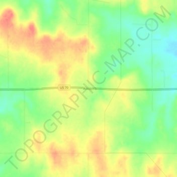
Name: Antioch topographic map, elevation, terrain.
Location: Antioch, Marshall County, Oklahoma, United States (34.08010 -96.84834 34.12010 -96.80834)
Average elevation: 269 m
Minimum elevation: 241 m
Maximum elevation: 296 m
Thank you for supporting this site ❤️
Make a donation
Make a donation
Other topographic maps
Click on a map to view its topography, its elevation and its terrain.
Lake Texoma
United States > Oklahoma > Marshall County
Normal elevation of the conservation pool varies from 615 to 619 ft (187 to 189 m) National Geodetic Vertical Datum (NGVD) depending on the time of year. The flood control pool extends to elevation 645 ft (197 m) NGVD. The lake has crested the dam's spillway at a height of 640 ft (200 m) five times: once in…
Average elevation: 213 m