
Make a donation
Khalapur topographic map
Click on the map to display elevation.
Make a donation
About this map
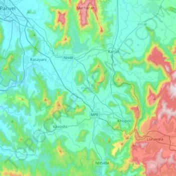
Name: Khalapur topographic map, elevation, terrain.
Location: Khalapur, Raigad, Maharashtra, India (18.68904 73.16729 19.00423 73.37310)
Average elevation: 191 m
Minimum elevation: 1 m
Maximum elevation: 942 m
Make a donation
Other topographic maps
Click on a map to view its topography, its elevation and its terrain.
Make a donation
Alandi
India > Maharashtra > Khed
Alandi (18°40′37.42″N 73°53′47.76″E / 18.6770611°N 73.8966000°E / 18.6770611; 73.8966000) is located on the bank of the Indrayani River, 18.8 km (11.7 mi) from Khed Taluka of Pune District, near the northern edge of the city of Pune. Alandi has an average elevation of 577 meters (1,893 feet).
Average elevation: 578 m
Make a donation
Ichalkaranji
India > Maharashtra > Hatkanangle
Ichalkaranji is located at 16°42′N 74°28′E / 16.7°N 74.47°E / 16.7; 74.47. It has an average elevation of 538 metres (1768 ft).
Average elevation: 562 m
Make a donation
Make a donation
Make a donation
Patan
India > Maharashtra > Patan
Patan is located at 17°22′N 73°54′E / 17.37°N 73.9°E / 17.37; 73.9. It has an average elevation of 582 metres (1909 feet).
Average elevation: 668 m
Linear Garden, Pimple Saudagar
India > Maharashtra > Haveli > Pimpri-Chinchwad
Average elevation: 562 m
Make a donation
Naldurg
India > Maharashtra > Tuljapur
Naldurg is located at 17°49′N 76°18′E / 17.82°N 76.3°E / 17.82; 76.3, 438 km from Mumbai.50 km from Solapur city It has an area of 7550 km2 and average elevation of 566 metres (1856 feet). The temperature ranges from 10.1 °C to 43.1 °C, and the average yearly rainfall is 760mm.
Average elevation: 563 m
Make a donation
Make a donation
Make a donation
Make a donation
अमरावती
Amravati is located at 20°56′N 77°45′E / 20.93°N 77.75°E / 20.93; 77.75. It has an average elevation of 343 meters (1125 feet). It lies 156 km (97 mi) west of Nagpur and serves as the administrative centre of Amravati District and of Amravati Division. The city is located near the passes…
Average elevation: 421 m
Make a donation
Ratnagiri
India > Maharashtra > Ratnagiri
Ratnagiri is located at 16°59′N 73°18′E / 16.98°N 73.3°E / 16.98; 73.3. It has an average elevation of 11 meters (36 feet). The Sahyadri mountains border Ratnagiri to the east
Average elevation: 30 m
Make a donation
Make a donation
Make a donation
Make a donation
Make a donation
Matheran
India > Maharashtra > Karjat
Matheran is an automobile-free hill station and a municipal council in the Karjat taluka of the Raigad district located in the Indian state of Maharashtra. Matheran is part of the Mumbai Metropolitan Region, and one of the smallest hill stations in India. It is located in the Western Ghats, at an elevation of…
Average elevation: 325 m
Make a donation
Make a donation
Make a donation
Make a donation
Make a donation
Make a donation
Make a donation
Make a donation
Make a donation