
Make a donation
Kinawayan topographic map
Click on the map to display elevation.
Make a donation
About this map
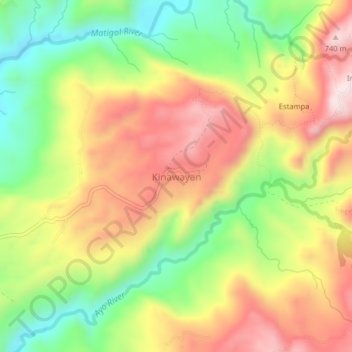
Name: Kinawayan topographic map, elevation, terrain.
Location: Kinawayan, North Cotabato, Soccsksargen, Philippines (7.37082 125.16377 7.41082 125.20377)
Average elevation: 512 m
Minimum elevation: 271 m
Maximum elevation: 757 m
Make a donation
Other topographic maps
Click on a map to view its topography, its elevation and its terrain.
Kabacan
The landscape is characterized by almost regular landscape of flat terrain. The high mountains and rolling hills leaping close to the river plus the narrow plains have varied topographical features. Other features are moderately sloping and strongly sloping.
Average elevation: 95 m
Make a donation
Antipas
Temperature ranges from 23 to 32 degrees Celsius, because of its topographic elevation of 320 meters above sea level and proximity to mountainous Bukidnon province, making it one of the cool places in Soccsksargen. The highest temperature is felt during the months of March and April, while the lowest is in…
Average elevation: 297 m
Make a donation