
Bonifacio topographic map
Interactive map
Click on the map to display elevation.
About this map
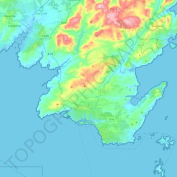
Name: Bonifacio topographic map, elevation, terrain.
Average elevation: 49 m
Minimum elevation: -5 m
Maximum elevation: 339 m
Other topographic maps
Click on a map to view its topography, its elevation and its terrain.
Guagno-les-Bains
France > Corsica > South Corsica > Guagno-les-Bains
Guagno-les-Bains, Poggiolo, Ajaccio, South Corsica, Corsica, Metropolitan France, 20125, France
Average elevation: 709 m